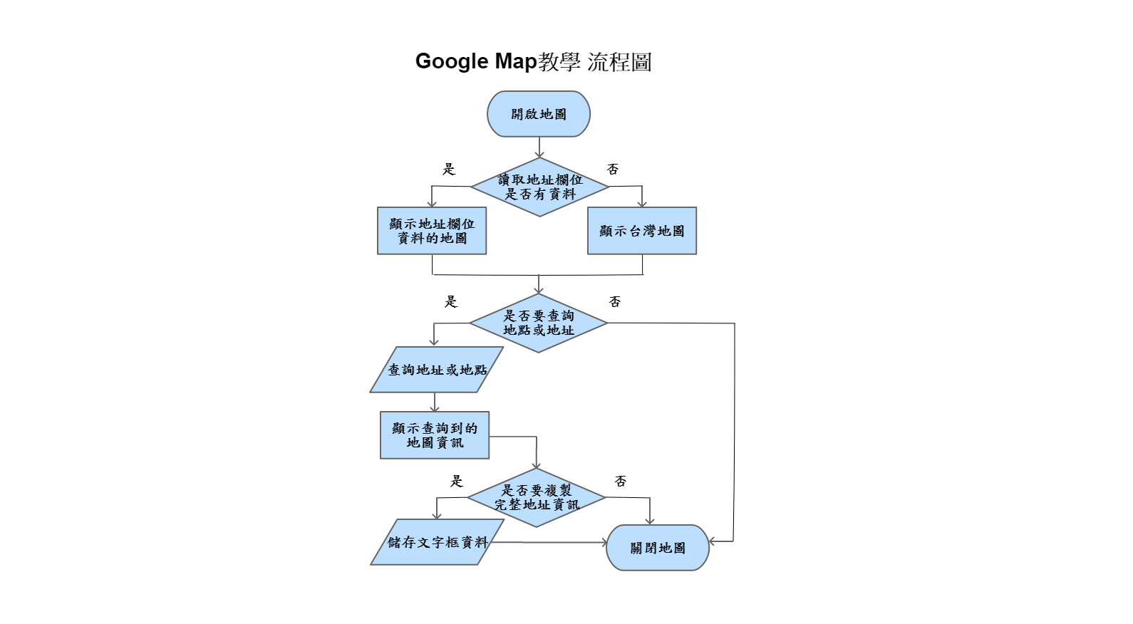
Google Map教學:操作地址
什麼是Google Map?是由Google公司像全球提供的電子地圖服務,用地圖規劃出地表、線條、符號等資訊。

架構
我們比較常看到的用法,在文字框輸入想要地點或地址之後點查詢,地圖會自動刷新顯示地標以及相關資訊。

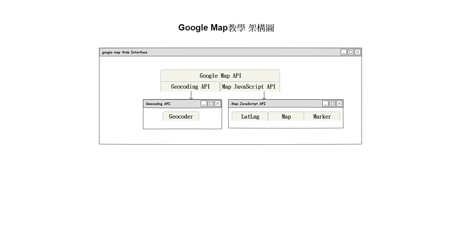
製作Google Map需要google提供的google map API才能實做,今天我們使用Geocoding API裡的地理編碼請求與Map JavaScript API來實做,以下介紹兩種的官網文件資訊
1. Geocoding API
Geocoding為地理編碼,將地址(如“1600 Amphitheatre Parkway,Mountain View,CA”)轉換為地理坐標(如緯度37.423021和經度-122.083739)的過程,您可以使用它來在地圖上放置標記或定位地圖。
您可以通過HTTP接口訪問Geocoding API。以下是地理編碼請求的示例。
地理編碼請求和響應(緯度/經度查找)
以下示例請求“1600 Amphitheatre Parkway,Mountain View,CA”的緯度和經度,並指定輸出必須採用JSON格式。
https://maps.googleapis.com/maps/api/geocode/json?address=1600+Amphitheatre+Parkway,+Mountain+View,+CA&key=YOUR_API_KE
您可以通過在Web瀏覽器中輸入URL來進行測試(請務必YOUR_API_KEY使用實際的API密鑰替換 )。響應包括地址的緯度和經度。
以下是JSON中的地理編碼響應示例:
{
   "results" : [
      {
         "address_components" : [
            {
               "long_name" : "1600",
               "short_name" : "1600",
               "types" : [ "street_number" ]
            },
            {
               "long_name" : "Amphitheatre Pkwy",
               "short_name" : "Amphitheatre Pkwy",
               "types" : [ "route" ]
            },
            {
               "long_name" : "Mountain View",
               "short_name" : "Mountain View",
               "types" : [ "locality", "political" ]
            },
            {
               "long_name" : "Santa Clara County",
               "short_name" : "Santa Clara County",
               "types" : [ "administrative_area_level_2", "political" ]
            },
            {
               "long_name" : "California",
               "short_name" : "CA",
               "types" : [ "administrative_area_level_1", "political" ]
            },
            {
               "long_name" : "United States",
               "short_name" : "US",
               "types" : [ "country", "political" ]
            },
            {
               "long_name" : "94043",
               "short_name" : "94043",
               "types" : [ "postal_code" ]
            }
         ],
         "formatted_address" : "1600 Amphitheatre Parkway, Mountain View, CA 94043, USA",
         "geometry" : {
            "location" : {
               "lat" : 37.4224764,
               "lng" : -122.0842499
            },
            "location_type" : "ROOFTOP",
            "viewport" : {
               "northeast" : {
                  "lat" : 37.4238253802915,
                  "lng" : -122.0829009197085
               },
               "southwest" : {
                  "lat" : 37.4211274197085,
                  "lng" : -122.0855988802915
               }
            }
         },
         "place_id" : "ChIJ2eUgeAK6j4ARbn5u_wAGqWA",
         "types" : [ "street_address" ]
      }
   ],
   "status" : "OK"
}
※要使用地理編碼API,您必須先在Google Cloud Platform控制台中激活API,然後獲取正確的身份驗證憑據。您需要在每個請求中提供API密鑰
單擊下面的按鈕以完成您將要執行的過程:
- 創建或選擇一個項目
- 啟用API
- 獲取API密鑰
2. Map JavaScript API
通過Maps JavaScript API,您可以使用自己的內容和圖像自定義地圖,以便在網頁和移動設備上顯示。Maps JavaScript API具有四種基本地圖類型(路線圖,衛星,混合和地形),您可以使用圖層和样式,控件和事件以及各種服務和庫來修改這些類型。
以下網頁顯示以澳大利亞新南威爾士州悉尼為中心的地圖:
<!DOCTYPE html>
<html>
  <head>
    <title>Simple Map</title>
    <meta name="viewport" content="initial-scale=1.0">
    <meta charset="utf-8">
    <style>
      /* Always set the map height explicitly to define the size of the div
       * element that contains the map. */
      #map {
        height: 100%;
      }
      /* Optional: Makes the sample page fill the window. */
      html, body {
        height: 100%;
        margin: 0;
        padding: 0;
      }
    </style>
  </head>
  <body>
    <div id="map"></div>
    <script>
      var map;
      function initMap() {
        map = new google.maps.Map(document.getElementById('map'), {
          center: {lat: -34.397, lng: 150.644},
          zoom: 8
        });
      }
    </script>
    <script src="https://maps.googleapis.com/maps/api/js?key=YOUR_API_KEY&callback=initMap"
    async defer></script>
  </body>
</html>
使用div名為"map"區塊元素呈現google map,用API的Map物件設定經緯度參數與地圖比例大小,在設定script標記加載Maps JavaScript API
- 我們使用聲明將應用程序聲明為HTML5
<!DOCTYPE html>。 - 我們創建了一個
div名為“map” 的元素來保存地圖。 - 我們定義了一個JavaScript函數,用於在中創建地圖
div。 - 我們使用
script標記加載Maps JavaScript API 。
要加載Maps JavaScript API,請使用以下示例中的標記:
<script async defer
  src="https://maps.googleapis.com/maps/api/js?key=YOUR_API_KEY&callback=initMap">
</script>
script標記中包含的URL 是JavaScript文件的位置,該文件加載了使用Maps JavaScript API所需的所有符號和定義。此script標記是必需的。
該async屬性允許瀏覽器在加載Maps JavaScript API時呈現您網站的其餘部分。API準備就緒後,將調用使用callback參數指定的函數。
該key參數包含應用程序的API密鑰
以下範例是在開啟地圖與查詢地圖時,顯示的google map的畫面:
1.開啟地圖
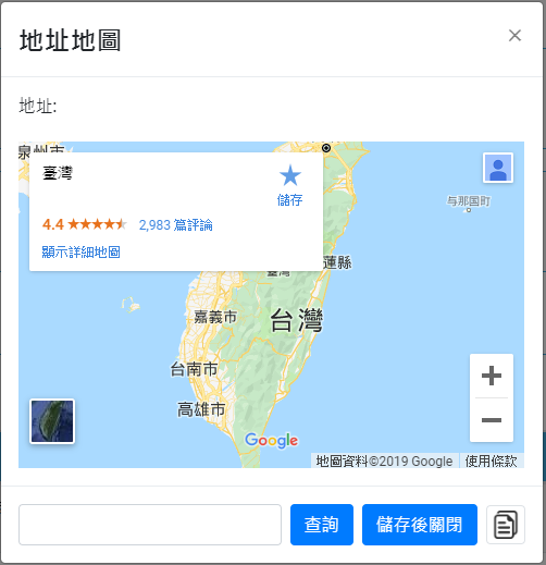
剛開啟地圖時預設是帶台灣地圖,這時可直接輸入地點或地址之後點選查詢,google map會重新讀取地圖
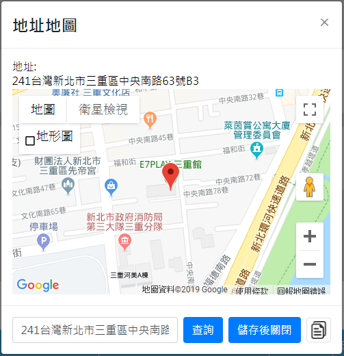
2.查詢地點
當查詢地點時,google map會重新讀取查詢到的地圖資訊,顯示地點的道路、附近地名等等。
上面顯示剛查詢地點後google map API提供完整地址,可點選右邊的複製圖示,複製地址到文字框做儲存。
以下程式碼是我使用Google Map API的Geocoding API與Map JavaScript API的寫法
//打開地圖
function openAddressMap(address,number){
    //經緯度變數
    var Latlng=null;

    //判斷查詢的地點或地址確認是否為空值
    if(address!='' && address!=undefined){
        //使用Geocoding API,目前要收費
        var geocoder = new google.maps.Geocoder();
        //用地點或地址先取得經緯度
        geocoder.geocode( { 'address': address}, function(results, status) {
            //狀態為OK才可以進行
            if (status == google.maps.GeocoderStatus.OK) {
                var latitude = results[0].geometry.location.lat();
                var longitude = results[0].geometry.location.lng();

                //使用Map JavaScript API的LatLng物件當經緯度
                Latlng = new google.maps.LatLng(latitude,longitude);
                $("input[name='copy_address']").val(results[0].formatted_address);

                //用變數在地圖使用哪些參數
                var mapOptions = {
                    zoom:17,
                    zoomControl:true,
                    center:Latlng,
                    mapTypeId: google.maps.MapTypeId.ROADMAP
                }

            //在頁面上使用Map JavaScript API的Map物件檔地圖(map與copy_map)
            var map = new google.maps.Map(document.getElementById('map'),mapOptions);
            var copy_map = new google.maps.Map(
                            document.getElementById('copy_map'),
                            mapOptions);
            //使用Map JavaScript API的marker物件設定經緯度
            var marker = new google.maps.Marker({
                position: Latlng
            });

                //id為map與copy_map區塊 set地圖物件
                marker.setMap(map);
                marker.setMap(copy_map);

                //顯示id為map區塊,隱藏id為copy_map區塊
                $("#map").show();
                $("#copy_map").hide();
                console.log(results[0].formatted_address);
            } else if (status == google.maps.GeocoderStatus.OVER_QUERY_LIMIT){
                //因API有請求計算次數,所以先在背後元素做兩個相同的地圖,當第二次使用可以用另外一张				  顯示達到減少重複相同查詢的次數
                $("#map").hide();
                $("#copy_map").show();
            } else {
                alert("Geocode was not successful for the following reason: "+status);
            }
        });
    }
    }
}

//複製完整地址功能
function copyAddress(){
    //先取得地址文字框資料
    var address = $("input[name='copy_address']").val();
    if(address==''){
        alert("請先查詢地點或地址");
    }else{
        $("input[name='address']").val(address);
    }
}
參考資料:https://zh.wikipedia.org/wiki/Google%E5%9C%B0%E5%9B%BE
https://developers.google.com/maps/documentation/geocoding/intro
https://developers.google.com/maps/documentation/javascript/tutorial